Original Story
There Was a Lost Continent Between Britain and Denmark. Scientists Are Now Mapping What Is Left of It.
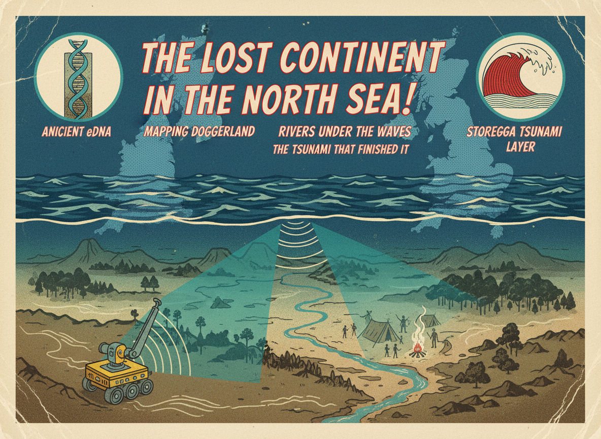
Doggerland was a real place. Roughly 12,000 years ago it was a landmass the size of modern France, connecting what is now Britain to the European mainland. Thousands of Mesolithic people lived there. Then the sea level rose and swallowed it. New DNA research, robotic seafloor mapping, and the discovery of an ancient tsunami layer are revealing what life there actually looked like, and what ended it.
Here is something most people do not know: Britain was not always an island.
As recently as 10,000 years ago, you could walk from what is now the east coast of England to the Netherlands. The floor of the southern North Sea was dry land. It had rivers, hills, forests, coastlines, and people living on it. Communities, probably numbering in the thousands, had settled there during the period after the last Ice Age when sea levels were significantly lower than they are today.
That land had a name before scientists gave it one, though none of the people who lived on it left written records. Today researchers call it Doggerland, after the Dogger Bank, a shallow section of the North Sea where fishing boats have been pulling up ancient bones and tools for over a century.
In 2026, the effort to map and understand this lost continent has accelerated significantly. New DNA research, robotic seafloor scanning technology, and the continuing analysis of an enormous wave deposit preserved in sediment layers are together painting the clearest picture yet of what Doggerland was and how it ended.
What Doggerland Looked Like
At its largest extent, around 16,000 years ago, Doggerland was an enormous territory. It stretched from what is now the Yorkshire coast westward across to the current shoreline of Denmark and the Netherlands. The area has been estimated at roughly 100,000 square kilometers, comparable in size to modern Great Britain itself.
The landscape was not arctic wasteland. In the period when people were actually living there, roughly 12,000 to 8,000 years ago, the climate had warmed significantly after the end of the last Ice Age. The land would have had rivers, wetlands, woodland areas, and abundant wildlife. Archaeologists and environmental scientists who have modeled the environment describe it as rich in resources: fish, shellfish, waterfowl, deer, and wild boar. It was, by the standards of the time, a desirable place to live.
The people who lived there were Mesolithic hunter-gatherers. They were not farming, not building cities, not writing. But they were organized, social, and capable. Similar communities from this period across Europe left behind sophisticated tools, artwork, and burial practices that show a complex inner life.
These people have left almost nothing behind. Their settlements were on a surface that is now 40 to 50 meters underwater. Their burial sites, their camps, their middens of food remains are sitting on the seafloor of the North Sea, mostly inaccessible to conventional archaeology.
What does reach the surface is what fishing boats accidentally dredge up. Over the past 150 years, North Sea trawlers working the Dogger Bank have brought up hundreds of ancient animal bones, flint tools, and fragments of wood preserved in the anaerobic conditions of the seabed. In 1931, a fishing boat famously dragged up a harpoon barb made from antler, preserved in a lump of peat, that dated to approximately 9,000 years ago. Someone dropped it there, or left it behind, long before anyone imagined there was a there there.
What the New Research Is Showing
In 2025 and continuing into 2026, researchers using robotic sensors and remote-operated vehicles have been conducting what is described as the most detailed mapping effort of the Doggerland seafloor yet attempted. The work is part of a broader push by North Sea-adjacent universities and research institutions to understand the submerged landscape before commercial activity further disturbs it.
The mapping is revealing that the seafloor of what was once Doggerland is not featureless mud. There are preserved river channels. There are ancient lagoon systems. There are areas of what appear to be raised ground that would have formed hills and higher terrain in the original landscape. The former coastlines are visible as distinct features in the sonar imagery, tracing the edges of what was once a shoreline that no modern human has ever seen.
A separate DNA study, reported in 2026 using ancient North Sea sediment samples, confirmed that Doggerland hosted temperate forests thousands of years earlier than previously believed. The sediment preserved ancient plant and pollen DNA showing that the landscape had warmed and developed complex woodland ecosystems at a time when researchers previously assumed it was still largely barren post-glacial terrain. This pushes back the timeline for human habitability of the region considerably.
How It Ended
The full story of Doggerland’s ending is one of the most dramatic environmental events in human pre-history, and it involved more than just slow sea level rise.
Sea levels were indeed rising throughout the period after the last Ice Age. The great ice sheets over Scandinavia and North America were melting, releasing enormous volumes of water into the world’s oceans. That process was gradual by human standards, meaning it happened over centuries rather than years, giving communities time to adapt and move.
But Doggerland had a different kind of ending too.
Around 8,200 years ago, a massive underwater landslide occurred off the coast of Norway. It is known today as the Storegga Slide. The slide involved approximately 3,500 cubic kilometers of seafloor sediment collapsing into the deep ocean in what was one of the largest submarine landslides in recorded geological history. The displacement generated a tsunami. A large one.
Evidence of that tsunami has been found in sediment layers around the North Sea, including in Scotland, Norway, and the Faroe Islands. In some coastal areas, the tsunami wave is estimated to have reached heights of 20 to 25 meters. Inland Scotland shows sediment deposits consistent with a wave traveling several miles inland.
If anyone was still living in Doggerland when the Storegga tsunami hit, which the evidence suggests they were since communities were still present in the coastal lowlands at that time, they would have had no warning. The wave would have crossed the shallow North Sea rapidly. Low-lying areas that were already gradually being lost to sea level rise were suddenly, violently inundated.
Researchers believe the combination of gradual sea level rise and the Storegga tsunami effectively ended human habitation of Doggerland. The people did not disappear. They moved. Communities that had lived in the lowlands for generations would have had to relocate to higher ground, which increasingly meant the shores of Britain, Ireland, and the continental European coast.
In a very real sense, some of the ancestors of the modern British population walked out of a continent that no longer exists.
What Might Still Be Down There
The seafloor of the North Sea is one of the most archaeologically significant unexplored territories on Earth. The conditions at the bottom are oxygen-poor, meaning organic materials, including wood, leather, plant fibers, and bone, can survive in reasonable condition for thousands of years. Sites that would have decayed to nothing on land surfaces may be partially preserved under the sediment.
That preservation is exactly what makes the current mapping efforts so significant. Identifying where the ancient river channels, lagoon edges, and elevated terrain once sat gives researchers targets. Future excavation, even in limited and technically difficult offshore conditions, could potentially retrieve material culture from communities that left almost no other trace.
The lost world of Doggerland is not entirely gone. It is sitting in the dark, at the bottom of a sea that covers a place where people once lived, fished, raised children, and did not know they were standing on something the ocean would eventually take.
Sources: ScienceDaily, Ancient DNA from North Sea Sediment Shows Doggerland Had Temperate Forests Earlier Than Believed, 2026, WebRef.org, The Golden Age of Discovery: What’s New in Archaeology for 2026, Wikipedia, Doggerland, Wikipedia, Storegga Slide

A Medieval Poet Described Hell as a Planetary Impact Crater 500 Years Before Science Had the Concept. Researchers Just Worked Out the Physics.
A new study presented at the European Geosciences Union General Assembly in Vienna in May 2026 makes a case that is extraordinary…
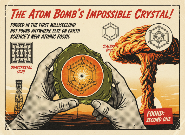
The First Nuclear Bomb Forged a Crystal That Doesn't Exist Anywhere Else on Earth. Scientists Just Found a Second One.
On July 16, 1945, at 5:29 a.m. in a remote stretch of desert in southern New Mexico, the United States Army detonated…

The Most Haunted Prison in America Opens Its Doors to Ghost Hunters Last Night. Over 200 People Died Inside.
The Ohio State Reformatory in Mansfield, Ohio, has been called the most haunted prison in America — and last night, May 14,…

A Neanderthal Had a Toothache 59,000 Years Ago. Someone Drilled It Out With a Stone Tool.
A tooth found in a Siberian cave just rewrote the history of medicine. Scientists confirmed on May 13, 2026, that a Neanderthal…